
Neighborhoods
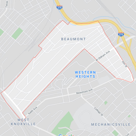
Beaumont
Beaumont is just north of Downtown Knoxville. It is traditionally bounded by I-275 to the north, Tennessee Avenue and Western Avenue to the west, Western Heights to the south, and Elm Street to the east. Its elementary school, Beaumont Magnet Academy, is known for its fine arts and museum programs.

Lonsdale
Londsale is located just over a mile northwest of Downtown Knoxville. Sharp's Ridge rises to the north of Lonsdale, Second Creek flows to the east, and the East Fork of Third Creek runs through the heart of the neighborhood. Lonsdale is traditionally bounded by Texas Avenue to the west, Heiskell Avenue to the north and the Western Heights housing development to the south. Knoxville College and Mechanicsville lie to the south, on the opposite side of Western Heights.

Parkridge
Parkridge is an urban neighborhood in Knoxville, TN located off Magnolia Avenue east of the city's downtown area. Homes in Parkridge vary from Queen Anne Victorian style to Arts & Crafts Bungalows. The houses are close together; with sidewalks connecting its residences to major roadways and businesses. Parkridge is less than 2 miles from downtown It's a racially diverse neighborhood, home to 2,774 people and 9 churches and 6 non-profit organizations.

Belle Morris
Belle Morris is a few miles north of downtown Knoxville. It is traditionally bounded by N Broadway to the west, Washington Pike to the north, Brice and Cherry Street to the east, and Hoitt Avenue to the south. Just to the west of Belle Morris you will find Jackie’s Dream restaurant, Fulton High School, and several businesses in Broadway Shopping Center.

Mechanicsville
Mechanicsville is a neighborhood in Knoxville, Tennessee, United States, located northwest of the city's downtown area. One of the city's oldest neighborhoods, Mechanicsville was established in the late 1860s for skilled laborers working in the many factories that sprang up along Knoxville's periphery. The neighborhood still contains a significant number of late-19th-century Victorian homes, and a notable concentration of early-20th-century shotgun houses.

Park City
Park City is a couple miles Northeast of Downtown Knoxville. It is traditionally bounded by I-40 and Chilhowee Park on the North, Cherry Street, Magnolia Avenue, and Spruce Street on the west, Lay Avenue on the South, and Beaman Street on the West. Magnolia Avenue goes through the center of the neighborhood which is home to several businesses, offices, and churches. The beautiful Knoxville Botanical Gardens border the south of this historic neighborhood.

Five points
Oakwood-Lincoln Park
Oakwood-Lincoln Park is bounded by North Broadway (US-441) on the East and the Old North Knoxville neighborhood and the former Southern Railway Coster Shop Yards to the south. It is bounded by Interstate 275 and Sharp's Ridge on the west. On the north it is bounded by the neighborhood of Arlington prior to the confluence of Sharp's Ridge and North Broadway. The Lonsdale neighborhood lies across I-275 to the west. First Creek flows through the eastern portion of the neighborhood near North Broadway.